

A Little Time Travel
A Little Time Travel
Sunday afternoon at Kavinish

By Pat Murkland
Driving out to the Cahuilla homelands of the Colorado Desert on a Sunday afternoon, the Interstate 10 freeway was loaded with traffic. People were streaming nonstop back to LA and points west from their desert weekend fun, some hauling their big-wheeled toys. Many others were traveling east with me, toward new adventures. I was planning on traveling back in time.
The air already felt warmer as I left San Gorgonio Pass and entered the desert, along a route that people have been traveling by foot, horse, stagecoach, train, car, for uncounted years. I was just reading how items traded along this major route in the year 1200 included obsidian, for making tools.1 I compared what that trail must have demanded with my Sunday-afternoon freeway, and decided the freeway wasn’t that bad after all.
Along Windy Point, all traffic slowed down suddenly because — well, it’s indeed quite windy there. Elder Ernest Siva (Cahuilla-Serrano) says the Serrano place name here is Ataman. He says: “That means the wind will hit you suddenly and make you say, ‘Atah!’ which means, ‘Ouch!’”
I drove on, passing Paac Yarra'nka' (Serrano), which literally means, “Water White” — Whitewater. Whitewater Canyon is the homeland of Cahuilla Wanakik (also spelled Wanikik) people.2 Although the desert was drier than dry as I drove by, many years ago, the Wanakik people called this canyon home, until a huge flood washed out their village. They eventually settled in the heart of what is now Morongo Reservation. The Wanikik name originates from wanish, or river, as Sean Milanovich of Agua Caliente Reservation explained recently to us. “After the flood, the river flowed over the village of the people, thus you have the name Wanipiapa.”3
I pulled off the freeway and passed 2021 spas, golf courses, “luxury condos,” restaurants and resorts. Finally, I reached a resort hotel that once hosted fun winter getaways for Hollywood stars. The walls boast their 1950s portraits, and the air filled with nostalgia, but no film glitz and glamour for me. I was there for older history. Much older: the Indian Wells Historic Preservation Foundation, and a program by archaeologist Bruce Love: “The Kavinish Village of Old Indian Wells.”
So many people tried to reserve a seat at this talk, it was standing room only. Kavinish (this News from Dorothy Ramon Learning Center newsletter discusses how this Cahuilla word means “dug out”) is an important Cahuilla place, the site of a famous walk-in desert well that once served as a major regional source of water. That’s how the modern-day city of Indian Wells got its name.
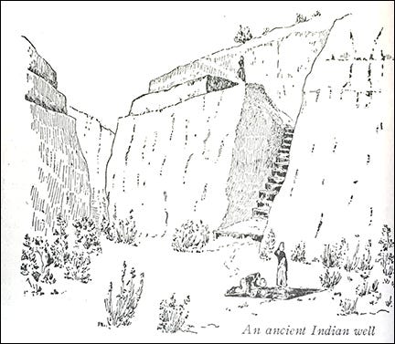
Revisiting this illustration: “An ancient Indian well,” Carl Eytel illustration, circa 1900-1906 in modern-day Indian Wells,in The Wonders of the Colorado Desert, 1906, by George Wharton James, Vol. 1: 264.
Sean Milanovich opened with an ancient Cahuilla song, and told about traditional cultural blessings. Then Bruce Love started peeling off the layers of time from Indian Wells.

Bruce Love, presenting “The Kavinish Village of Old Indian Wells.”
He showed us the perspectives of map makers: in 1959 (a golf course already is on this map), and moving steadily backward in time, map after map, arriving in 1904, when the well is benchmarked on the map, along with Cahuilla homes. The well is also marked on a map of the 1860s stagecoach road called the Bradshaw Trail. The stagecoach road followed traditional Native American trails from water source to water source across the Colorado Desert.
Next, we hear from travelers, including U.S. Army Lt. R.S. Williamson, out surveying for possible railroad routes in 1853. He writes about a deep walk-in well, with steps downward that have been lined with clay, clay hardened so much it has become like stone. One of the Romero expeditions (1823-1826) also stops by Kavanish.
Finally, way back in time: In 1925 Akasem Levi (sēwahilem) of Torres tells the ancient migration legend of the sēwahilem clan to anthropologist William Duncan Strong4. The story begins, “Aswitseī (eagle flower) stopped first at Happy Point (near Indian Wells) where he left the imprint of his elbows and knees in the rock …”
(In this Cahuilla story as told in 1939 by Francisco Patencio5, Eagle Flower travels through San Gorgonio Pass and through Palm Springs. “Then he went down to Indian Wells, where the others had settled before, and here he saw the Palm tree. And he recognized the Palm tree as one of his own people. Then they talked to one another, and both began to cry together. Then Eagle Flower, he wanted to be a palm tree and live there also. He tried standing very straight and strong, first on the right side and then on the left side, but his power was not strong enough, and he could not do it. The Indians say that Um Naw, the Great Spirit, who lives everywhere, would not allow him to do it.”)
Lastly, archaeologist Bruce Love shared the work in finding more than 30,000 artifacts in an archaeological survey and excavation that his firm conducted preceding a development project in the Indian Wells area some years ago. The sites dated back more than 1,000 years, he said — another way of recording the area history. A discovery: many unusually shaped projectile points apparently unique to Kavanish.
It seemed odd to return to 2021 traffic after all the time travel. Yet as I traveled home, I could see the silhouetted mountains, and the sky just above them glowing with the sunset. In the darkening sky rose a tiny sliver — the New Moon. I thought of the Palms, growing near the desert water where Moon’s reflection would shine. Just as she did in ancient times.
Thank you!
Join Dorothy Ramon Learning Center in saving and sharing Southern California’s Native American cultures, languages, history, and traditional arts:
Give a tax-deductible donation. ASK FOR MORE INFO.
Read, share, subscribe to News from Dorothy Ramon Learning Center. It’s free. Send your feedback and ideas: EMAIL. Thank you from Editor Pat Murkland, December 9, 2021.
Lerch, Michael K., ethnographic report in Yamisevul: An Archaeological Treatment Plan and Testing Report for CA-RIV-269, Riverside County, California, Authors Jeffrey H. Altschul and Steven D. Shelley, Statistical Research Technical Series, No. 9, 1987, p. 21.
This story about the flood was told by Malki Museum and museum co-founder Jane Penn of Morongo Reservation, whose father, William Pablo, was a Wanakik Cahuilla puul, or medicine man. Her grand-uncle, Yginio Gabriel, and grandfather, Pablo Gabriel, were both Wanakik Cahuilla ceremonial leaders.
A.L. Kroeber in 1925 recorded Wanupiapayum; Ruth Benedict in 1924 heard Wanapupayam. Edward Gifford in 1918 recorded Wanakiktum; C. Hart Merriam wrote down Wah-ne-ke-tam or Mahl'-ke. William Duncan Strong in 1929 recorded wanikiktum; Lowell John Bean in 1960 recorded Wanakik Wanakik, according to Native American Place Names in the San Bernardino National Forest, San Bernardino and Riverside counties, California, Lowell John Bean and Sylvia Brakke Vane, submitting officers and editors for Cultural Research Systems Inc., 1981 report for the U.S. Forest Service, Arcadia office, contract number 53-9JA9-0-212, Table 2, “San Gorgonio Pass Groups as identified by ethnographers.”
Aboriginal Society in Southern California, 1929, repr. Malki Museum Press 1972, “The Migration Legend of the Sewahilem Clan,” pp. 86-87.
Patencio, Francisco, and Margaret Boynton. Stories And Legends of the Palm Springs Indians, 1943, Palm Springs Desert Museum, pp 41-44