

Invisible Cemetery
Invisible Cemetery
Forgotten Landmarks

By Pat Murkland
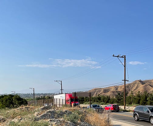
San Timoteo Canyon, a rural inland Southern California canyon in the foothills of the San Jacinto Mountains, has served as an important travel route for centuries. The other afternoon, the winding, narrow San Timoteo Canyon Road was jammed bumper-to-bumper with commuters trying to get home. Nearby railroad tracks awaited the next Union Pacific freight train. Blasts of the train horns echo frequently through the canyon’s browned hills.
My trip to the canyon was not about traveling from place to place, however. I went there to reflect about a final resting place. There lie about 50 to maybe 100 people — a cemetery that is unmarked, unheralded, and seems mostly forgotten. I didn’t see the cemetery because it’s invisible. Here’s the story that I could find so far of San Timoteo Chapel, (roughly) 1875-1895, and the cemetery where people were buried until 1904.
Intersection of Native Homelands
Many, many years earlier, Native American people walked along this canyon, part of a major trail leading from the Pacific coast into the gateway of the deserts.1 Branch trails in the canyon no doubt led to area Native American communities. The canyon’s yearlong creek offered water, and the surrounding lands gave many opportunities for hunting and gathering valuable foods and other resources. The canyon remains important to Native American communities to this day.
The area in older times is believed to have been a boundary between the Serrano of the San Bernardino Valley to the northwest, the Serrano from the Yucaipa area to the east, and the Wanakik Cahuilla to the southeast toward San Gorgonio Pass.2 Starting around 1851, Juan Antonio, the famed Cahuilla who was a principal tribal leader in the 1840s-50s, lived not far from modern-day El Casco, in the village of Sáxhatpah, also the Cahuilla name for the canyon, which means, “Place of the Willows.”3 He died in the canyon in a smallpox epidemic in 1863.
Adobe Chapel
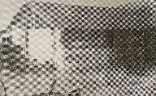
Undated photo of the San Timoteo Chapel from Readings in Diocesan Heritage, Vol. 10, Ethnic Diversity in Diocesan History, by R. Bruce Harley.
Immigrants from the East, including the Frinks, Singletons, and Haskells, began settling in the canyon and developing ranches in the 1850s. Other settlers included descendants of early colonist families and those intermarried with Native Americans, including some who had lived in the area possibly since the mid-1840s. The coming of the trains to the region in 1875 brought an influx of railroad workers, mostly Mexicans.
Father P.J. Stockman, a Roman Catholic priest who served a region that included San Bernardino, Agua Mansa near Riverside, San Timoteo, and San Jacinto, saw a need for a regional chapel. In 1875 he persuaded volunteers to build a one-story adobe chapel at the intersection of what is now San Timoteo Canyon and Live Oak Canyon roads, near the modern-day border of Riverside and San Bernardino counties.4
The late R. Bruce Harley, former San Bernardino Diocese archivist, wrote: “In a 1944 interview, a Mrs. Romero, then living near the new St. Mary’s Church in Redlands, reminisced about the days of the little church seventy years previously. Her mother was a Mayan Indian and her father a Mexican. She was born in a wagon while the family was in route from Arizona to California in 1862. Her father was one of those who helped to build the chapel. The building was erected on the Diaz Ranch; it was believed that Senor Diaz had previously named the canyon as San Timoteo.”5
The tiny chapel was used until about 1894, when Sacred Heart parish was established in nearby Redlands. The adobe building then slowly eroded as calls to restore the chapel and recognize the cemetery slowed down and finally halted altogether in the 1940s. The canyon chapel finally disintegrated.
Forgotten Cemetery
Local historian Peggy Christian remembered that the Diaz, Lopez, Albanez, and Romero families had given land for the chapel’s accompanying cemetery and that burials had continued since the 1860s. 6
The cemetery was about a half-mile from the chapel and shows on the Government Land Office plat map of 1876, according to a report prepared in 1984 for the U.S. Army Corps of Engineers. 7
The numbers given for those buried in the cemetery over a 40-year period range from 50 to 100. Many graves were unmarked, “and as with many of the early cemeteries, no sexton’s record of burials was either maintained or survived as a documentary source,”8 according to the late diocese archivist, R. Bruce Harley. Workers who were killed or who died of illness during the construction of the railroad were buried in the cemetery. Anglos and Native Americans also rest in the graveyard, according to R. Bruce Harley and family accounts. Five known memorials are listed in findagrave.com, including that of a 4-year-old burn victim and members of the pioneer Covington family.
In 1904, authorities ordered the burials to cease at the “Mexican Graveyard” due to insufficient and improvised tombs, and a newspaper account noted that death certificates or burial permits at the cemetery were “unheard of.” 9
Existing tombstones later apparently were stolen, destroyed, and even removed by family members. By 1992, R. Bruce Harley wrote, “There is no sign that it had ever been a cemetery.”
In 2021
I did not trespass the other day onto the private ranch land where the cemetery rests. I did stop at a roadside patch of dirt near the bustling intersection, where many commuter vehicles were lined up to stop at the four-way stop signs.
I was looking for a pepper tree.
The historian R. Bruce Harley had written about San Timoteo Chapel, “As the years passed, the chapel’s adobe structure deteriorated so that a century later only a few chunks remained under the outstretched branches of a huge pepper tree which undoubtedly had been planted in the 1870s to shade the site.” 10
Around 1992, he photographed that pepper tree and was glad to see it still standing.
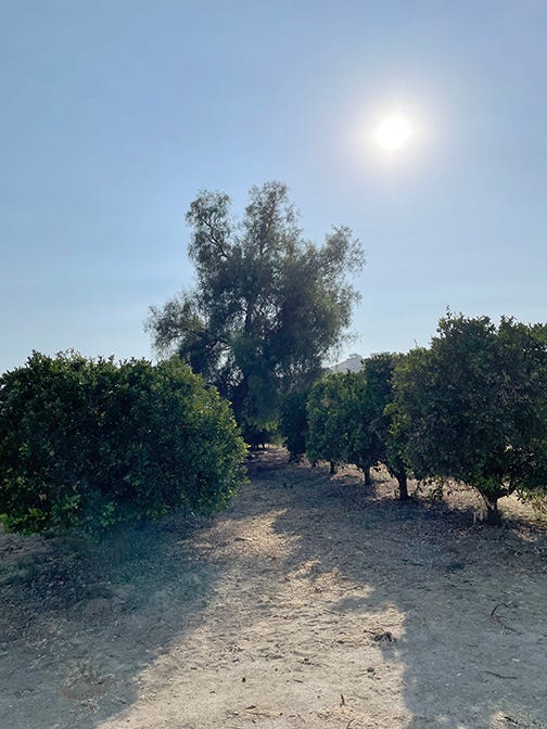
Nearly 30 years later, in 2021, I stood at the roadside and did the same.
Rest in peace, little chapel and people of San Timoteo Cemetery.
Thank You!
Dorothy Ramon Learning Center’s 501(c)3 nonprofit mission is to save and share Southern California Native American cultures, languages, history, and traditional arts.
We love to hear from our community: EMAIL. Subscribe, share! Thank you! Pat Murkland, Editor. September 8, 2021.
Johnston, Francis, “San Gorgonio Pass, Forgotten Route of the Californios?” in Journal of the West magazine, Vol. 3, No. 1, January 1969, pp 125-136
Altschul, Jeffrey H., and Martin R. Rose, Michael K. Lerch, Man and Settlement in the Upper Santa Ana River Drainage: A Cultural Resources Overview, report prepared for the Los Angeles District U.S. Army Corps of Engineers, Tucson, AZ: Statistical Research, Inc. 1984, p. 93.
Orthography from Sean Milanovich of Agua Caliente Reservation, researcher on Juan Antonio and the Treaty of Temecula.
Harley, R. Bruce, Readings in Diocesan Heritage, Vol. 10, Ethnic Diversity in Diocesan History, 1992, Diocese of San Bernardino, p. 26
Ibid, pp 26-27.
Christian, Peggy, Historic San Timoteo Canyon: A Pictorial Tour, Myths and Legends, Sagebrush Press, Morongo Valley, 2002.
Man and Settlement in the Upper Santa Ana River Drainage, p. 94. (see footnote 2)
Harley, R. Bruce, Readings in Diocesan Heritage, Vol. 10, Ethnic Diversity in Diocesan History, 1992, Diocese of San Bernardino, p. 30
Ibid, p. 32
Ibid, pp 28-29