
Discover more from News from Dorothy Ramon Learning Center
By Pat Murkland
San Bernardino County Museum in Redlands and Palm Springs Art Museum are two large Inland Southern California museums that recently have displayed land acknowledgements pointedly recognizing Native American cultural homelands and the inclusion of First Nations in education for all ages.
Today’s discussion focuses on a different kind of recognition: official historic landmarks.
At the continuing Palm Springs Modernism Week, dedicated to iconic Desert Modern mid-century architecture and design, we were impressed with the quantity of buildings and sites — about 15 — that the nonprofit Palm Springs Modern Committee has helped add to the National Register of Historic Places since forming in 1999 to save an old fire station. This process can offer many hurdles and requires research and determination. Bravo!
Our curiosity ensued:
What Native American sites in the same region are recognized nationally? The National Register of Historic Places isn’t only about buildings. The National Register defines itself as “the official list” of the nation’s cultural resources deemed worthy of preservation.
“Authorized by the National Historic Preservation Act of 1966, the National Park Service's National Register of Historic Places is part of a national program to coordinate and support public and private efforts to identify, evaluate, and protect America's historic and archaeological resources.”
A key point, therefore, of naming national historic landmarks, is to teach everyone about that place’s importance in our United States history. Here are a few Native American places in these Native American desert homelands that currently, officially are on the National Register of Historic Places:
Palms in Andreas Canyon (Photo by MKeimPhD courtesy of Wikimedia Creative Commons)
ANDREAS CANYON (listed in 1973), and TAHQUITZ CANYON (listed in 1972). Ancestral home to Cahuilla people, the Indian Canyons (Andreas, Murray, and Palm canyons) and Tahquitz Canyon are in preserves owned, protected, and managed by Agua Caliente Band. “These canyons are especially sacred to the Cahuilla people today and are historically important to scientists and nature lovers … Rock art, house pits, foundations, irrigation ditches, dams, reservoirs, trails, and food preparation areas still exist in the canyons,” according to the tribal website. Information on visiting: https://www.indian-canyons.com.
The high-water mark of the former Lake Cahuilla can be seen in desert mountains. (USGS Photo)
COACHELLA VALLEY FISH TRAPS (listed in 1972) are a long-ago souvenir from when much of the low desert was underwater, part of a freshwater lake that is believed to have been up to 100 miles long, 34 miles wide, and 300 feet deep. The manmade features, stones arranged and stacked at different levels, are believed to have served as fish traps. Access to these is not usually made public, because it may betray them to vandalism or destruction — one of the constant dilemmas of preserving these ancient places while trying to educate people about the deep cultural meanings. However you can learn more and see a panoramic view of the lake site from the Ancient Lake Cahuilla Overlook, a trail in La Quinta.
McCOY SPRING PETROGLYPHS (listed in 1982), a longtime crucial water source for people and animals, tells old stories with rock art. The site is part of the Palen/McCoy Wilderness Area managed by the Bureau of Land Management and it’s about a ten-mile hike in to the spring.
NORTH CHUCKWALLA MOUNTAINS PETROGLYPH DISTRICT (listed in 1981), and NORTH CHUCKWALLA MOUNTAINS QUARRY DISTRICT (also listed in 1981) also illustrate the dilemma of recognizing fragile archaeological sites as significant to our national history while needing to preserve what they teach us. The North Chuckwalla site, in Chemehuevi lands, was along a trail believed to have been used by many Native American tribal groups. The prehistoric quarry, which dates back centuries, provided rock for making many tools.
Both historic districts were created as mitigation after environmental studies were done for construction of a high-transmission power line. There is no real public access. So why list these on the National Register of Historic Places? Because, the research that went into claiming the designation can move forward and deepen our understanding of the Indigenous people who made these sites, and help everyone recognize their place in national history.
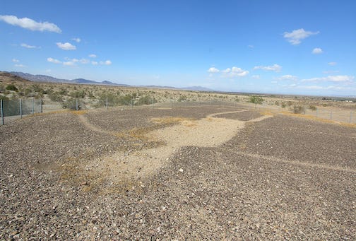
Geoglyph near Blythe, courtesy of Wikimedia Creative Commons.
EARTH FIGURES OF CALIFORNIA-ARIZONA, also known as the BLYTHE INTAGLIOS (listed in 1975), giant figures incised in the earth along the Colorado River that represent humans and animals. Those near Blythe tell a story of how a National Register designation doesn’t necessarily save a landmark from damage or destruction. They suffered through the years from tire tracks and other human-caused erosion. This Arizona Republic news article describes the efforts of local tribes to protect them. Several sites about 15 miles north of Blythe offer public access for viewing. More information here.
Landmarks not yet on the National Register
Getting a site listed on the National Register of Historic Places involves hurdles that can include much time, research, and money. During the process the application goes first to the state. Then after review, if deemed successful in documenting national historic significance, the application proceeds to a federal review.
Many Native American Creation sites, mountains such as Ayaqaych (San Jacinto Peak), springs, and other sacred, culturally important sites are not currently listed in the National Register of Historic Places. (A few are listed as county or state landmarks, that is, of more local importance. )
Elder Ernest Siva (Cahuilla-Serrano), president of Dorothy Ramon Learning Center, named some desert landmarks he believes worthy of National Register of Historic Places designation:
• Oasis of Mara, the Serrano Creation site near Twentynine Palms.
• Wanipiapa, Whitewater Canyon, home of the main Wanakik (also spelled Wanikik) Cahuilla lineage.
• Isilsīveyaiutcem, ancestral home of the Siva lineage in Martinez Canyon in the Santa Rosa Mountains.
• Kavinish, Indian Wells, is a county landmark and a “state point of historical interest” but not on the National Register.
And the rocks by Windy Point and — “There are so many more,” he said.
Share your important Native American historic landmarks with us: EMAIL. Thank you from Editor Pat Murkland, February 23, 2022.
Dorothy Ramon Learning Center, led by Elder Ernest Siva, is a 501(c)3 nonprofit that saves and shares Southern California Native American cultures, languages, history, and traditional arts. We welcome your donations. (MORE INFO.)
Subscribe to News from Dorothy Ramon Learning Center
We save and share Native American cultures.


