

Trails

By Pat Murkland
When stagecoaches began crossing Inland Southern California toward Arizona about 160 years ago, the travelers found themselves in foreign lands. That is, the canyons, foothills, mountains, and especially deserts were foreign geography, and also foreign nations to them. These places are Native American homelands.
What happened when the stagecoaches rolled through, starting around 1862? Today we’re telling a few true Old West tales about Native American resourcefulness and tribal sovereignty.

Replica of historic stagecoach travels along a surviving piece of the old Bradshaw Trail at the Gilman Historic Ranch and Wagon Museum, once a stagecoach stop, in Native American homelands in Banning, California. Beyond the trees is a view of Morongo Reservation. (Pat Murkland Photo)
Trails Across Homelands
After gold was discovered in early 1862 along the Colorado River in Arizona, the rush for riches demanded an efficient overland route from San Bernardino to Arizona, local historian Steve Lech explained in a May 12, 2022, presentation to the San Gorgonio Pass Historical Society.
A stagecoach road wasn’t like our modern-day interstate freeway, zipping directly from point A to B.

A Banning, California, mural by Butch Murphy depicts stagecoach travel.
Stagecoaches relied on horses, and a horse needs to drink at least 10 gallons of water a day to remain physically safe. When eight horses or mules haul a single freight wagon, or six horses pull a passenger and mail coach, that’s a lot of water. It can mean life or death for animals and humans. The Romero expedition, for example, turned around and left behind a trail of dead and dying horses, after getting lost and failing in late 1823-early 1824 to find an overland route between the San Gabriel Mission near Los Angeles and the Colorado River. 1
Native Americans already had a centuries-old network of major and minor trails and knowledge of available water. “The trails of the Indians were everywhere,” Cahuilla leader Francisco Patencio of Palm Springs remembered in 1939.2
“They led up all the canyons. There were hunting trails for the men, and used by the women to gather the seed, nuts, plums, and acorns, so many things. They led from the land of one tribe to another. All the Indians did their part to keep the trails clear. The trails were sacred to the Indians.”

Map of the Bradshaw Trail, courtesy of Steve Lech, as shared with San Gorgonio Pass Historical Society.
It was in the Cahuilla village of Toro in the Salton Sink that explorer and entrepreneur William Bradshaw got lucky in the spring of 1862. He spoke with Cabezon, the net or leader, and possibly a Maricopa Native American from Arizona who remains unnamed. They entrusted him with valuable information: “They showed Bradshaw, by drawing a map, the principle … trade route across the Colorado Desert,” historian and trail expert Francis J. Johnston writes.3
The route is known today (and by official decree in 1974 of the Riverside County Board of Supervisors) as the Bradshaw Trail.
“And he [Bradshaw] immediately followed it as the last leg of his journey to the mines,” Johnston writes. “Along the south side of the Orocopias and Chuckwallas they found Lone Palm, Dos Palmas, Canyon Creek, Tabeseca Tank (a natural rock tank that fills up with rain water), Point of Mountains, Chu-cul-wallah, and thence to the River by way of Mule Mountains and what is now Palo Verde Valley.”4
“These are all named after Euro-Americans now,” the late Cahuilla Elder Alvino Siva observed in 1999, “but these were our trails.”5
Renting Native Lands
With Bradshaw’s success, different stagecoach lines soon began running both day and night between San Bernardino and what became known as La Paz, Arizona. Stagecoaches everywhere were robbed, and horses were stolen, amid other catastrophes, but Francisco Patencio said, “Here on the desert, where there was no water, and nothing to eat for so many travel days apart, the Coachella Valley most always had peace.” 6
(Well, not always, as some stories attest about stopping thieves with gunfire.)
While a route with water stops was an absolute must, changing out the horses also was necessary. So was feeding animals and people. Many stagecoach station operators of the 1860s paid the Native Americans for water and land, and for food for people and horses, according to Chief Patencio.7
One such station operator, Hank Brown, proprietor around 1866 for the Toro and Martinez stations in what is present-day Torres-Martinez Reservation, and also apparently later a general manager for a stage line between San Bernardino and Yuma, “stopped where the Indians lived, because that was where the food and water were,” Francisco Patencio remembered.8
“He made agreements with the Indians to pay for water and land for his stations and his horse corrals. This he always did.” Brown also bought food from Native Americans to feed passengers.
Carl Eytel illustration in The Wonders of the Colorado Desert (southern California) Its Rivers and Its Mountains, Its Canyons and Its Springs, Its Life and Its History, Pictured and Described: Including an Account of a Recent Journey Made Down the Overflow of the Colorado River to the Mysterious Salton Sea, Volume 1, By George Wharton James, 1906, Boston, Little, Brown and Co.
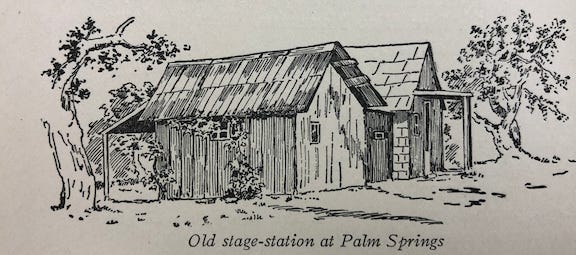
Jack Summers, a station proprietor from 1862-1876, rented land on what is now N. Palm Canyon Drive in Palm Springs,9 and bought adobe mud from the local Cahuilla to build the station, Patencio said. Corrals were made from mesquite branches, and stables were fashioned as ramadas, with poles holding up a roof of palm leaves or brush.
Summers also hired Native Americans to grow barley for his station’s horses. The crop project failed in drought, according to Patencio. All the stations soon succeeded in hiring Native Americans to gather native bunch grasses, paid for by the weight, Patencio remembered.
“After the horses get used to this grass, it makes fairly good feed. We boys often went to gather the grass, but not so far as the older Indians. They went in the early morning to the mountains, and did not get home until late in the afternoon. We boys were well pleased to earn 25 or 50 cents and not go so far.”
At Indian Wells (Kavinish), similar arrangements were made to rent the site and water, and to buy the native grasses, Patencio said.
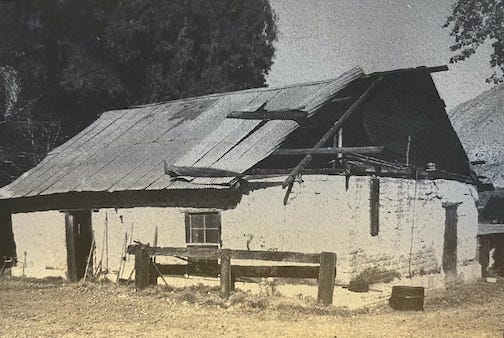
What remained of the former Whitewater adobe stagecoach station in 1972. (Courtesy of the Riverside County Historical Commission)
Speaking Cahuilla
Very early settlers in Highland Springs in the San Gorgonio Pass, the Smith family, established a second cattle ranch along with a stagecoach stop at the desert’s edge at Whitewater near Wanipiapa, home of the Wanakik (also spelled Wanikik) Cahuilla. The stagecoach station was operated by Frank Smith starting in the 1860s. He was 16. His nephew, French Gilman, whose home in the Banning area was also a stage stop and is in 2022 a Riverside County park and stagecoach museum,10 liked to hang out there as a small child. There he learned much about native plants and wildlife, gaining fame later in life as a knowledgable ornithologist and botanist. Also later in life, in his roles with the Indian Service, he was an ally of Native Americans.
Francisco Patencio remembered how members of the Smith family spoke Cahuilla. “There were few white people here at that time,” Patencio said. “He [the teen Frank Smith] came and learned the Indian language very well. He sang all the Indian songs, and played their games, hunted, ate, and slept with them. The Indians loved him very much. He could come as often as he liked. The Indian people would have been glad for him to live with them always.”11
The era of stagecoaches ended by the 1880s, when trains connected North America’s east and west ends and replaced horses with horsepower. By then, Native Americans already were losing much of their homelands and were pushed onto reservations as more and more newcomers arrived.
Chona Dominguez remembered in 1955 how she lived in Palpúniviktem (now part of Torres-Martinez Reservation) and watched Chinese and Native American workers lay the railroad tracks.12
It was another path toward the end of the old ways.
Thank you
Dorothy Ramon Learning Center, led by Elder Ernest Siva (Cahuilla-Serrano), saves and shares Native American cultures, languages, history, and traditional arts. We welcome your EMAIL. Thank you from Editor Pat Murkland, May 18, 2022.
See: Lowell John Bean and William Marvin Mason, Diaries And Accounts Of The Romero Expeditions In Arizona And California, 1823-1826. Published 1962, Palm Springs Desert Museum, Palm Springs, California.
Francisco Patencio, as told to Margaret Boynton, Stories And Legends of the Palm Springs Indians, 1943, Palm Springs Desert Museum, p 70.
Francis J. Johnston, The Bradshaw Trail, revised edition, © 1987 by Francis J. Johnston, Historical Commission Press, Riverside, California, p. 58.
Ibid.
Quoted by Pat Murkland in “Once Free to Roam,” in “Family Album,” The Press-Enterprise newspaper, Oct. 10, 1999, special section, p. 10.
Patencio, p. 62.
Patencio, pp. 60-63.
Patencio, p. 60.
This was on the site of the former Desert Inn, razed in 1967, which later became the site of Desert Fashion Plaza, razed in 2013.
The Gilman Historic Ranch and Wagon Museum, 1901 Wilson Street, Banning, CA, 92220, will offer stagecoach rides and other activities as part of its annual Western festival and art show from 10 a.m. to 4 p.m. on May 21 and 22, 2022.
According to The San Gorgonio Pass Rendezvous, a family history written in 2016 by Virginia Sisk, Frank Smith went to Alaska in 1899, where he and his wife are believed to have drowned.
Hansjakob Seiler, Cahuilla Texts with an Introduction, © 1970, Indiana University Publications, Language Series Monographs, v. 6, Editor, C.F. Voegelin, p 148, story told in Cahuilla in 1955 by Chona Dominguez. (Ornithology as given by Seiler.)